
Open User Map
Open User Map lets you create a WordPress map with visitor submissions, approval workflows, and powerful customization without coding or a Google.
Visit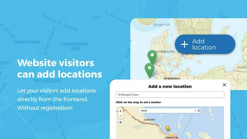
About Open User Map
Open User Map is a powerful, user-friendly WordPress plugin that transforms any website into an interactive, community-driven mapping platform. Designed for website owners, developers, and organizations of all sizes, this plugin enables visitors to contribute locations, routes, and areas directly on a map without requiring any technical expertise or coding knowledge. The core value proposition of Open User Map lies in its simplicity and accessibility: it eliminates the need for a Google Maps API key, complex setup procedures, or backend programming. Instead, users can install the plugin and have a fully functional, customizable map running in minutes. The plugin supports a complete workflow for user-generated content, including frontend submissions, approval workflows, and powerful customization options. With over 15,000 active installs, a perfect 5-star rating, and recognition as the number two map plugin on WordPress.org, Open User Map has established itself as a trusted solution for creating maps that grow and evolve with community input. It is particularly valuable for businesses, tourism websites, real estate platforms, event organizers, and local directories that need to crowdsource location data while maintaining editorial control through approval workflows. The plugin's architecture supports both free and premium features, making it accessible for basic needs while offering advanced capabilities for professional applications.
Features of Open User Map
Frontend Submissions and Editing
Enable your website visitors to add and edit locations directly on your map through an intuitive frontend interface. When a user clicks the "Add location" button, they can place a marker and submit details such as name, description, and custom fields. All submissions await your approval before going live, ensuring quality control. The editing capability allows users to update their existing locations, keeping the map current and accurate without requiring administrator intervention. This feature empowers communities to contribute meaningful data while maintaining moderation authority.
Lines and Areas
Go beyond simple location markers by adding routes, paths, zones, and regions directly to your map. This feature allows you to highlight trails, service areas, event grounds, neighborhoods, construction zones, or any custom shape that helps visitors understand your map at a glance. Distances and area sizes are calculated automatically, so routes and polygons include helpful measurements right out of the box. This capability is essential for mapping hiking trails, delivery zones, or event perimeters with precision and clarity.
Custom Image as Map
Upload any image and transform it into a fully interactive map, whether it is an overlay, floor plan, event layout, game map, product diagram, campus guide, or seating chart. Users can place markers directly on top of the image with the same powerful functionality as a traditional map. Add locations, display custom fields, enable filtering, and create an engaging, clickable experience tailored exactly to your use case. This feature opens up creative possibilities for non-geographic mapping applications.
Advanced Filter Interface
Create a filter sidebar that appears next to your map, allowing visitors to filter locations by any custom field you have configured. You can also add custom HTML content sections to display additional information or branding. This gives users a clearer, more intuitive way to explore your mapped data. Combined with marker categories and custom fields, the advanced filter interface provides a robust search and discovery experience that helps users find exactly what they need on your map.
Use Cases of Open User Map
Community-Driven Local Business Directories
Create a comprehensive map of local businesses, restaurants, and services where community members can add and update listings. Users can submit new businesses, edit hours, add reviews, and upload photos. The approval workflow ensures all information is verified before going public. With custom fields for categories, opening hours with live "Open Now" indicators, and star ratings, this use case provides an authoritative local resource that grows organically through community participation.
Tourism and Travel Guides
Build an interactive travel guide map where visitors and locals can share points of interest, hiking trails, scenic viewpoints, and hidden gems. The Lines and Areas feature allows mapping of hiking routes and park boundaries, while custom fields capture essential details like difficulty level, best seasons, and accessibility. The upvote and rating system helps highlight the most popular destinations. This creates a dynamic, constantly updated resource that enhances the visitor experience for any tourism destination.
Event and Festival Mapping
Map out event grounds, festival layouts, or conference venues with precision using the Custom Image as Map feature. Upload a floor plan or site layout, then allow attendees to pin food vendors, restrooms, stages, and information booths. The advanced filter interface helps attendees quickly find what they need, while the approval workflow ensures official event information remains accurate. This use case improves attendee experience and reduces staff burden during large events.
Real Estate and Property Showcasing
Create a property map where real estate agents and property owners can list available homes, apartments, or commercial spaces. Each listing can include custom fields for price, square footage, number of bedrooms, and property type. Buyers can filter by their requirements using the advanced filter interface, and the Lines and Areas feature can highlight school districts, flood zones, or neighborhood boundaries. This transforms a simple property listing into an interactive, data-rich exploration tool.
Frequently Asked Questions
Do I need a Google Maps API key to use Open User Map?
No, you do not need a Google Maps API key. Open User Map is designed to work without any external API keys or complex integrations. The plugin uses its own mapping technology, which means you can set up and start using the map immediately after installation. This eliminates the common headache of API key management, billing concerns, and usage limits associated with Google Maps.
Can I moderate user-submitted locations before they appear on the map?
Yes, Open User Map includes a built-in approval workflow. When a visitor submits a new location or edits an existing one, the submission is held for moderation. As the administrator, you can review each submission, approve it to make it public, or reject it. This ensures that only accurate, appropriate, and high-quality content appears on your map while still allowing community participation.
Is there a free version of Open User Map available?
Yes, there is a free version of Open User Map available for download on WordPress.org. The free version includes core functionality such as frontend submissions, approval workflows, and basic customization. For users who need advanced features like Lines and Areas, Custom Image as Map, Advanced Filter Interface, Upvotes and Likes, Star Ratings, and Opening Hours, there is a PRO version available with a 7-day free trial that does not require a credit card.
What types of custom fields can I add to location markers?
Open User Map supports a wide range of custom field types to suit your specific data collection needs. You can add text boxes for descriptions or contact information, links to external websites, checkboxes for boolean attributes, dropdown menus for categorical selections, and a dedicated Opening Hours field type that displays beautifully styled business hours with a live "Open Now" indicator. This flexibility allows you to capture exactly the information that matters for your mapping project.
Similar to Open User Map

Supadrop lets you instantly create a live link from a ZIP, HTML, or PDF file, with no coding or setup required.

WhatTime.dev provides real-time global time zone conversion, meeting planning, and local time details for teams and travelers worldwide.

Webleadr instantly finds and contacts businesses without websites, helping you effortlessly generate web design leads from anywhere.

Wafler provides advanced DDoS protection with customizable firewall controls and real-time mitigation to keep your services secure and running.

Idearium crafts impactful websites and marketing strategies that drive growth and enhance your online presence.

Effortlessly host and share files with instant URLs using FilexHost's simple drag-and-drop interface.

CrawlKit is an API-first platform for effortless data extraction from any website, streamlining your data collection.

Best Boilerplates is a comprehensive directory to compare SaaS starter kits by features, tech stacks, and pricing.